The transformation of the Manzanares and the M-30 in Madrid
Alfons Belman
Master of Civil Engineering student, Universidad Politécnica de Madrid
When choosing a case for this blog contribution, I thought it would be interesting to look at the River Manzanares as it passes through Madrid and how its relationship with the M-30 has changed in recent years. For a long time, this stretch of the river was practically covered by the ring road, with heavy traffic, constant noise and riverbanks taken up by carriageways and ramps that hardly anyone used as public space. The Manzanares was more a space designed to let cars go through than a place where people could walk or do sport.
On top of that, the river itself had already been heavily modified by different weirs and structures that were built years ago. All of this, together with the presence of the M-30, meant that the river ended up trapped between walls, with very little vegetation on the sides and hardly any relationship with the surrounding neighborhoods. For this reason, I think it is a good example of how an infrastructure can go from being poorly integrated into the city to becoming the backbone of a large linear park, thanks to the tunnelling of the M-30 and later renaturalisation projects that try to recover the river as an ecological corridor and public space.
Before Madrid Río, the section of the M-30 that runs alongside the Manzanares was basically a large motorway stuck to the riverbed. The road followed the valley of the river and occupied almost all the available space, with several lanes in each direction, junctions, flyovers and access ramps that kept taking away space from the banks. In the aerial image in Figure 1 you can clearly see how the river channel is surrounded by different branches of the M-30, with very little free space left on the margins.
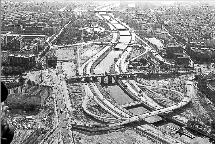
Figure 1. Aerial view of the River Manzanares and the M-30 as an urban motorway before the tunnelling works.
Source: historical photograph shared on social media (unknown author).
From a citizen’s point of view, this turned the Manzanares into a sort of internal border within the city. Crossing from one side to the other was not easy, with few bridges designed for pedestrians, constant noise and an atmosphere that did not invite you to stop. The infrastructure did its job of moving cars, but at the cost of breaking the relationship between the city and its river, and wasting a corridor that could have had much greater social and environmental value.
In the 2000s the city decided to turn this situation around with a major project to transform the M-30/Manzanares corridor. The main idea was to put the motorway underground along several sections next to the river and free up the surface in order to create a large linear park, which we now know as Madrid Río. The tunnelling works were part of the “Madrid Calle 30” project and meant a very strong intervention on the existing infrastructure, with tunnels several kilometers long and a complete reorganization of the junctions in this area. The scale of this operation can be clearly seen in Figure 2, where the excavations and the structures of the new tunnels next to the old Vicente Calderón stadium are visible.
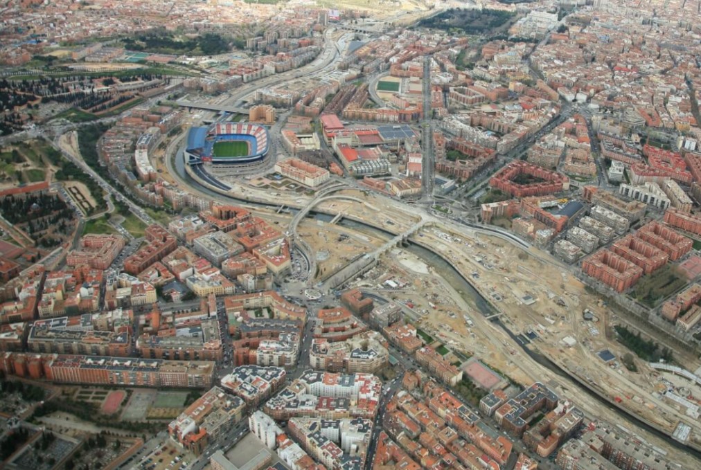
Figure 2. Tunnelling works on the M-30 next to the River Manzanares, as part of the Madrid Calle 30 project.
Source: EMESA M-30, “Historia de la M-30”.
Once the surface space had been freed up, the City Council launched a design competition for the new park. The result was a project combining green areas, pedestrian and cycle paths, playgrounds, sports areas and new bridges and footbridges that connect the neighborhoods on both sides of the river much better. In this way, the old corridor that seemed to be designed only for traffic started to become a corridor that understood public space and the Manzanares in a different way.
With the arrival of Madrid Río, the landscape has changed so much that, if you compare the before-and-after images, it almost looks like a different place. Where there used to be cars and asphalt, there are now tree-lined promenades, lawns, playgrounds, sports courts and paths for cycling or running. The river has gone from being something that almost went unnoticed in the landscape when seen from the car to becoming a place that people go to on purpose to spend time, do sport or simply walk. This change can be seen very clearly in Figure 3.
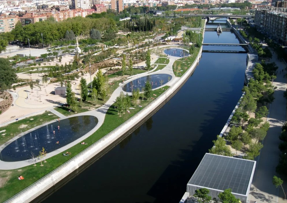
Figure 3. Section of Madrid Río along the River Manzanares after the M-30 was placed underground.
Source: Madrid Nuevo Norte.
The way people move between neighborhoods has also changed. Thanks to the new bridges and footbridges, and to the fact that the M-30 is no longer on the surface, it is much easier to cross from one side of the river to the other without having to deal with traffic or large junctions. The park works as a continuous public-space corridor that connects different parts of the city and, at the same time, brings the river closer to everyday life for local residents. Added to this is the renaturalisation of the river channel in recent years, which has allowed more riverside vegetation and river-related wildlife to appear, so that the Manzanares is no longer just the backdrop of the park, but also a small patch of nature inside Madrid.
Although the result of the operation on the surface is very positive, the project also has several aspects that are worth looking at carefully. The first one is that it is a very expensive intervention, both because of the complexity of putting a road like the M-30 underground and because of the overall scale of the works. It is not a solution that can simply be applied anywhere, because it requires a huge investment and a very clear decision to prioritize this corridor over other possible projects in the city.
In addition, there has been debate around Madrid Río about its effects on nearby neighborhoods. On the one hand, many residents have gained in quality of life thanks to the reduction of surface noise, the improved landscape and the appearance of new places to walk and spend free time. On the other hand, there has also been talk of rising housing prices and processes of gentrification in some areas close to the park, which raises the question of who really benefits from this kind of large urban operation. In the end, the case of the Manzanares and the M-30 shows that transforming an infrastructure can greatly improve public space, but it always involves political and economic decisions that do not affect the whole city in the same way.
Looking at the whole picture, the case of the Manzanares and the M-30 sums up quite well how an infrastructure can shape the way people live in a city, and how it can also be corrected. For years the river was reduced to a leftover space dominated by traffic, but the tunnelling and the creation of Madrid Río have made it possible to recover that corridor for people and to open the door to a certain renaturalisation of the river.
From the point of view of Engineering and Territory, I think the main lesson is that it is not enough for a road to work well in terms of capacity; we also have to think about where it is placed, what space it occupies and what effects it has on its surroundings. In this case the solution arrived late and was very expensive, but it shows that it is possible to rethink infrastructures that used to act as barriers and turn them into an opportunity to improve public space and the relationship between the city and its river.