Laura González-Portal Lomba. Máster ICCP.
The boom in mining in the Caudal River mining basin means that Mieres, with an area of around 1,400 km2, would become the epicenter of the Asturian metropolitan area for a few decades.
Initially an area of great agricultural and livestock activity, with exploitation of the river’s resources, it soon undergoes a strong change. The growing process of industrialization and the discovery of coal deposits, as well as the development of the railroad, generates the need to supply a great amount of materials, causing a transformation in the city, leading to people leaving behind rural life with an increase in population.
This population growth generated a lack of control and accelerated urban development, with the creation of subsidized housing, insufficient land available and a railroad that ran through the municipality. However, it is not only society that is changing. The large number of mining and steel operations in the area led to a strong metamorphosis in the landscape.
In the territorial model of this mining city a certain evolution can be seen. In the second half of the 19th century, the factories were installed at the bottom of the main valleys. This led to the traditional villages becoming urban centers, as well as a historical settlement on the slopes encouraged by intensive mountain mining. Later, the territorial system of Mieres in the 20th century paid special attention to the wide flat grounds of the river valleys, where the vertical mining shafts would be installed. In this way, residential areas were interspersed with industrial areas, generating a socially diverse space. Primacy is given to companies, giving rise to a completely saturated space. Likewise, the mountainous condition of the territory forces a linear growth close to the river. But the increasingly decadent coal industry marked a new time of uncertainty.
Currently, the territorial layout is marked by the use of the limited opportunities that exist due to the limited space available, instead of being the product of strategic planning that involves a restructuring of the area. In any case, the number of incoherent elements, despite attempts to provide a certain logical order, is still numerous.
The lack of agility in the management of the funds and in orienting the city towards a process of decarbonization, are some of the main causes that explain the failure of the territorial regeneration plans.
In 2009, the council of Mieres had a population of around 44,000 inhabitants, of which 25,000 live in the urban area of Mieres. Currently, it has 38,428 residents (2018) and the municipality has a population of 22,741, mostly adult and elderly population, coming from the nearby nuclei of the council that are becoming depopulated. To alleviate the problem, there has been a strong investment in infrastructure, such as the mining highway, the creation of industrial parks to revive the economy of the place, as well as the construction of a university campus and a regional hospital. All this with the aim of configuring a new reality and a thread of hope for the Basins.
The challenge of consolidating a new model of unified and sustainable city, based on an efficient system of connections in the limited space available, makes La Mayacina a starting point for this new territorial pattern.
La Mayacina is an area of approximately 13,000 m2, which has not been developed in four decades since the site was abandoned by some old metal workshops. The Mieres Town Council, co-financed by the European Regional Development Fund, will carry out this project, which aims to include this area in the city through the construction of a park and square. The relevance of this planning lies in the contribution of this space as a new sustainable urban axis. The lighting by LEDs, the creation of green areas, in addition to the construction in nearby streets of parking lots for electric cars, are some of the elements that will achieve an improvement in the environmental quality of the place.
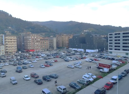
Figure1. Actual disposal of La Mayacina. Formerly, the train used to go through this area
Source: Rodríguez Gutiérrez, Fermín y Menéndez Fernández, Rafael (2019): “Contracción territorial y ordenación urbana para encarar el ciclo post-minero en Mieres (Asturias-España)”, en Ciudades, 22, pp. 99-122.
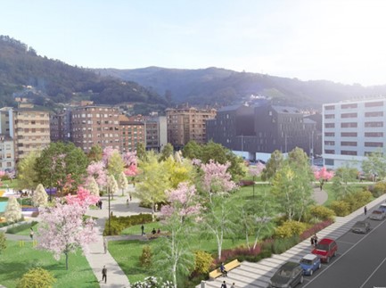
Figure 2. Graphics showing the display of the plaza-park project
Source: Rodríguez Gutiérrez, Fermín y Menéndez Fernández, Rafael (2019): “Contracción territorial y ordenación urbana para encarar el ciclo post-minero en Mieres (Asturias-España)”, en Ciudades, 22, pp. 99-122.
For all the above reasons, it is important to emphasize the importance of territorial planning as a key factor in the quality of life and the layout of cities. By means of good and coherent planning strategies, a town that has fallen into disrepair, such as Mieres, and like so many others in Spain, can revive itself thanks to urban revitalization plans.