At first, in order to treat the issue of the Urban Action Plans in Madrid, a review of the definition of a PAU, and its most important characteristics must be made in order to make a territorial analysis of the effects produced.
A PAU (Urban Action Program) is a figure of spatial planning make urban extensions in a city, which may be arised from the demand for building, due to the increase in population, and because the demand responds to the need for building with a price affordable, making the concept of a diffuse city.
This situation has disadvantages in energy expenditure and time involved, because doing any daily activity (work, studies, leisure, etc.), this activity is conditioned by a displacement of more distance than if it were produced in a compact city.
The origin of this type of urban planning is in article 44 of the BOE of September 15, 1978, although its popularity increases in the 90s.
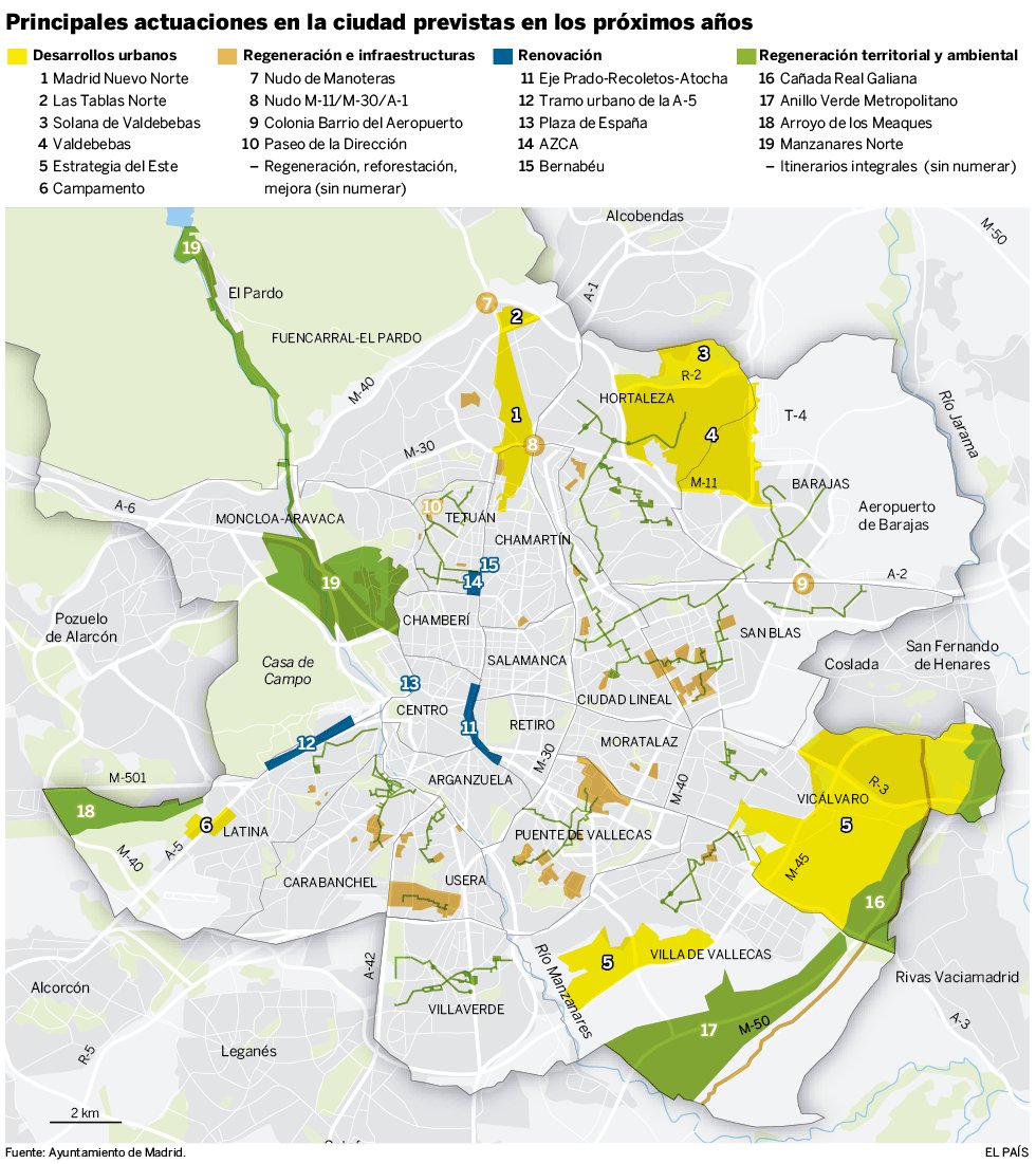
Since then and up to the present time, 15 urban developments have been carried out in Madrid, as can be seen in the location map of Madrid City Council:

We can see that the new developments set a new urban crown representing more existing floor surface available for growth of the city. This is, for the north and for the southeast, and with less intensity, for the southeast.
Among all these new developments, the most representative are: Las Tablas, Carabanchel, Montecarmelo, Sanchinarro and Ensanche de Vallecas, whose surface and building data are summarized in the following table of land uses:
|
|
Residential |
Industrial |
Tertiary sector |
Endowments |
|||||
|
|
Area (m2) |
Urban building (m2) |
Area (m2) |
Urban building (m2) |
Area (m2) |
Urban building (m2) |
Area (m2) |
Urban building (m2) |
|
|
Arroyo del Fresno |
271,418 |
324,000 |
– |
– |
19,878 |
50,000 |
417,044 |
133,546 |
|
|
Montecarmelo |
546,815 |
854,700 |
– |
– |
50,498 |
136,600 |
1,960,687 |
127,302 |
|
|
Las Tablas |
530,768 |
1,198,867 |
– |
– |
192,100 |
301,133 |
2,900,132 |
600,550 |
|
|
Sanchinarro |
643,719 |
1,291,602 |
58,152 |
17,183 |
153,196 |
190,200 |
3,014,208 |
56,515 |
|
|
Ensanche de Carabanchel |
661,881 |
1,162,931 |
125,967 |
257,255 |
45,221 |
63,011 |
2,732,534 |
692,699 |
|
|
Ensanche de Vallecas |
1,026,652 |
2,430,727 |
62,724 |
58,000 |
275,676 |
350,317 |
5,808,000 |
609,186 |
|
Characteristics of the PAU of Madrid and problems detected:
As explained, the streets of new developments are characterized by their large surface, as a result of the conception of urban typology of diffuse city. For its configuration, this type of city means for its inhabitants the need to travel by car for everyday activities, making life happen in their own homes in these neighborhoods, reducing urban model in which the square is a meeting point for society.
This dependence on traveling by car conditions the land uses, building large commercial areas, which are accessible mainly by car, and that replace the traditional urban space and create a greater physical separation of uses, so we find that buildings have a use purely residential, without businesses, which have been moved to different areas for such use.
This circumstance is strengthened and conditioned by the great width of the streets of the neighborhoods and has consequences on public transport, because its operation responds to the principle of critical mass, that is, it needs a minimum demand that justifies that its implementation offers a benefit Social.
Therefore, a small or decreasing demand causes the frequency decrease and public transportation is of lesser quality. This circumstance is also applicable to endowments.
From the point of view of demography, between 2017 and 2023 the population of Madrid is expected to be reduced by approximately 80,000 inhabitants (Source: Municipal data bank), and does not justify the creation of large residential spaces.
This circumstance means that the developments built do not exceed the expectations created for housing demand, creating a problem of underutilized spaces, which has been tried to compensate with the construction in these neighborhoods of large buildings. A strength that can be generated from this situation is that this type of buildings, if they are of large companies (cases such as Telefónica or BBVA) can attract public transport, but in practice, has not had positive influence on the neighbors.
The last comment is about the planning of the road layout, clearly influenced by the rest of the geometric features.
As these developments have been located between city circuits, a barrier effect occurs from the first moment. Some of the streets of this type of development have high traffic intensities because they suppose a continuation of the motorways of entrance to the city, but it has been observed that there is a great number of streets that end abruptly without leading anywhere, preceded by stretches with traffic-organizing elements, such as roundabouts in sections where traffic is predictably low, leaving evidence that the demand for this type of development has been less than expected, or perhaps, that they were built knowing that there would not be. An example is the following satellite image:
Author: Fady Awad Núñez.