Artículos
2024

Lamíquiz-Daudén, P. J., Baquero-Larriva, M. T., Ramirez-Saiz, A., & Carpio-Pinedo, J. (2024). Proximidad y herramientas de planificación en España: los casos de Barcelona, Castelló de la Plana, Pontevedra, Valladolid y Vitoria-Gasteiz. Ciudad Y Territorio Estudios Territoriales, 56(220). https://doi.org/10.37230/CyTET.2024.220.17
Este estudio analiza las políticas relacionadas con la ciudad de proximidad en Barcelona, Castelló de la Plana, Pontevedra, Valladolid y Vitoria-Gasteiz, para identificar cómo han incorporado este principio en sus planes, estrategias y acciones y comprender los valores y limitaciones de cada tipo de plan (Agenda Urbana Española, AUE; Plan General de Ordenación Urbana, PGOU; Planes de Movilidad Urbana Sostenible, PMUS; etc.). Tras el análisis estructurado de los documentos aprobados, destacan varios elementos de gran potencial: el uso de una nueva unidad espacial, la “superilla”, de fuerza comunicativa comparable a la de la ciudad de 15 minutos, y además nuevo ámbito para concen-trar las actuaciones urbanísticas en la ciudad consolidada; la existencia de una gran cantidad de acciones en los cuatro ejes de la proximidad (accesibilidad, uso del suelo, espacio público y participa-ción); y el potencial de la AUE como herramienta de planificación integrada urbanismo-movilidad.

Baquero Larriva, M. T., & Lamíquiz Daudén, F. (2024). Flowers of proximity in Spain: understanding local context priorities. SUPTM 2024 conference proceedings. DOI: 10.31428/10317/13588
Proximity planning models are globally implemented to promote ecological, health, and equity ob-jectives. As a difference with accessibility, an objective and continuous variable, it is thought that the idea of proximity is intrinsically subjective and reliant on the context, without a universal model that can be applied to all cities due to their diverse social, economic, and geographical backgrounds. The study aims to evaluate the efficacy of the “flower of proximity” as a new participatory tool to examine accessibility preferences based on proximity in Madrid and Beasain and to build a more objetive picture of shared, social, needs. It acknowledges the necessity for easy understandable and context-specific proximity instruments to promote effective urban planning strategies that address the unique needs of the local populace.

Lamíquiz-Daudén , P. J.; Baquero , M. T..; Martín , J. C. Integrating proximity-centred accessibility policies in the Governance of Local authorities in Spain. SUPTM 2024 conference proceedings. DOI: 10.31428/10317/13585
This research aims to broach the conceptual and policy framework of prox- imity accessibility by exploring its understanding by planning practitioners in Spain. To do this, we used an online survey distributed to 385 practitioners obtaining a sample of 105 valid responses. Most practitioners agree that proximity policies are already consid- ered in territorial/strategic planning, although they believe that it is still to be thoroughly applied at the municipal level. Regarding other policies, they consider very relevant the promotion of walking and cycling linked to limit the use of private cars, as well as equity (gender, age, ability, etc.) and health-related actions.

Ramírez-Saiz, A., Baquero Larriva, M. T., Lamiquiz Dauden, F. J., & Higueras García, E. (2024). Proximity planning for healthier cities: lessons from Barcelona, Bergamo, Ottawa, and Portland. Cities & Health, 1–23. https://doi.org/10.1080/23748834.2024.2414555
Healthy cities and proximity urban models have become rising trends in the planning discussion. Urban environments that foster walkability, green infrastructures and intergenerational spaces play a key role in developing healthier cities. Urban proximity strategies, such as Paris’ 15-minute city, are now renowned for aiming to have essential daily services close to home. However, they came from long-standing urban traditions such as the Neighbourhood Unit in the U.S. or Time Planning in Italy or Germany. This study explores how four cities, Barcelona, Bergamo, Ottawa and Portland that showcase some of these traditions, integrate proximity and urban health into their planning policies. Despite the diversity of scales, approaches and tools adopted (regional, territorial or urban; land use, health or mobility; plans, regulations or recommendations), some common principles arose that yield a more purposeful vision of proximity. It includes improving urban communication, promoting sustainable transport, fostering intergenerational inclusion, and developing green and pedestrian infrastructures. The article underscores the fact that, notwithstanding the different strategies, the four cities are successfully integrating proximity and health into their city plans. The presented discussion provides a framework to guide these kinds of efforts in future cases.
2023
López-Lambas, M. E., Alonso, A., Ramírez-Saiz, A., & Pereira, A. (2023). These Boots Are Made for Walking: A Qualitative Study on the Perceived Barriers to Pedestrian Mobility in Madrid. Future Transportation, 3(1), 111-132. https://doi.org/10.3390/futuretransp3010008
As an active mode of transportation, walking has proven to be an effective strategy to tackle environmental problems while improving health. The current paper highlights the main factors that either encourage or deter pedestrians in their daily trips by analyzing the arisen discussions in three different Focus Groups (FGs), which were later synthesized into factors ranking according to their positive or negative outcomes. The results help identify these factors and show how a variety of target groups (seniors, young adults, middle-aged adults, divided by male and female perspective) perceive the city in different ways: younger adults prioritize accessibility and quality of the infrastructure, females highlighted the insecurity suffered during nighttime trips, and older adults emphasized the relevance of street maintenance. Finally, the benefits of walking on physical and mental health are viewed positively amongst all target groups, considering walking as a means to help people reduce stress.
Alonso, A., Monzón, A., Aguiar, I., & Ramírez-Saiz, A. (2023). Explanatory Factors of Daily Mobility Patterns in Suburban Areas: Applications and Taxonomy of Two Metropolitan Corridors in Madrid Region. ISPRS International Journal of Geo-Information, 12(1), 16. https://doi.org/10.3390/ijgi12010016
Understanding the characteristics that shape mobility could help to achieve more sustainable transport systems. A considerable body of scientific studies tries to determine these characteristics at the urban level. However, there is a lack of studies analyzing those factors for the heterogeneous zones existing in the suburbs of big cities. The study presented in this paper intends to fill this gap, in the context of two metropolitan corridors in the Madrid Region. Correlation analyses are used to examine how mobility patterns are affected by socioeconomic and urban form variables. Then, a cluster analysis is carried out to classify the types of zones we may find in the suburbs. Results show that the main characteristics leading towards higher car use are low urban density, few local activities, a high percentage of children, and a low percentage of seniors. As for the variable distance to the city center, it does not explain car use. Moreover, some remote areas have many walking trips. This is well understood in the cluster analysis; there are zones far away from the city center but that are dense and well provided for, which work as self-sufficient urban centers. Results reinforce the theories underlying polycentrism as a solution to the urban sprawl challenge.
2022
Daudén, F. J. L., Pinedo, J. C., & Moreno, M. B. (2022). Genealogía de la ciudad de 15 minutos: aproximación a los conceptos. Cuadernos de investigación urbanística, (142), 29-39. https://doi.org/10.20868/ciur.2022.142.4885
La importancia de acceder a todos los servicios urbanos relevantes en menos de 15 minutos de viaje es fácil de entender, pero parece que, no por casualidad y debido a las restricciones de movilidad por la pandemia del COVID-19, ha cobrado por fin protagonismo en varias ciudades por todo el mundo. Si bien la idea de Carlos Moreno no es nueva, su reciente inclusión en la agenda política en un cierto número de ciudades sugiere que ha llegado a un punto de madurez en la discusión política, abarcando acciones para reducir las emisiones, cuestiones asociadas al tráfico, la reconquista del espacio público por parte de los peatones y la promoción de la interacción y participación, la defensa de estilos de vida más saludables y el envejecimiento activo. Al ser un concepto en desarrollo, la ciudad de 15 minutos requeriría de su validación científica, como han empezado a hacer diversos equipos en ciudades como Barcelona o Nápoles y, ulteriormente e integración en la “caja de herramientas” profesional de planificadores urbanos y de transporte, para llegar a generalizarse. En ese sentido, parece imprescindible entender tanto sus antecedentes conceptuales como las claves de su puesta en práctica. En esta ponencia, se exploran los principios y estrategias enunciados por Carlos Moreno y su equipo (Moreno et al. 2020) y se relacionan con antecedentes y conceptos más propios de la disciplina. Por ejemplo, el “Cronourbanisme” (la vinculación de ritmos y espacios cotidianos, al decir de Moreno), con la “Planificazione temporali” italiana o con el Urbanismo de género; la “Topo-philie” (apego al lugar) con el “Place-making” o el “New urbanism” o el de “Chronotopie (uso diferenciado de un lugar según la temporalidad) con los cierres temporales de calles o el Urbanismo táctico, a través del caso de Paris y también en otros menos conocidos pero muy similares, como Portland (20-minutes neigborhoods, 2012), Melbourne (20-minutes neigborhoods, 2017) y Ottawa (15-minutes neigborhoods, 2019)
Ramírez Saiz, A., Alonso, A., Jiménez Martín, D., & Lamíquiz, P. (2022). Can Proximal Environments Prevent Social Inequalities Amongst People of All Ages and Abilities? An Integrative Literature Review Approach. Sustainability, 14(19), 12911. https://doi.org/10.3390/su141912911
Although many studies are currently examining the city of proximity as a way to promote sustainable and environmentally friendly cities, few consider it meaningful to achieve an “inclusive” mobility model for people of all ages and abilities, including people with disabilities, children, or the elderly. This literature review paper focuses on the extent to which the city of proximity can provide inclusive mobility and reduce inequalities in the urban scene, thus achieving social sustainability. Out of the 256 references analysed under an integrative review methodology, only 10 delivered solid results. One of the main contributions of this paper is an indicator and sub-indicator system to improve the integrative methodology in urban studies, which led to the identification of several incoherencies in proximity models in terms of accessibility and design for all risking fostering urban with these policies. Although the mentioning of vulnerable collectives may mean a rise in inclusion awareness, one of the most relevant outputs of this paper is the lack of specific measures to revert the disadvantageous situations that conventional mobility planning delivers, as well as the neglection to use proximity actions to promote inclusive and socially resilient urban cities.
2021
Carpio-Pinedo, J., Benito-Moreno, M., & Lamíquiz-Daudén, P. J. (2021). Beyond land use mix, walkable trips. An approach based on parcel-level land use data and network analysis. Journal of Maps, 17(1), 23-30. https://doi.org/10.1080/17445647.2021.1875063
Land use mix is one of the cornerstones for urban sustainability, in opposition to functional segregation and zoning policies. Land use mix is a prerequisite for urban proximity dynamics, healthier lifestyles and public space vitality. However, methodological shortcomings to its measurement remain and are responsible for the unexpected weak association with pedestrian activity. This study puts forward a novel method to reframe, measure and map land use mix as ‘walkable trips’, a closer approach to its benefits based on functional and spatial complementarity. The method draws on newly available cadastral microdata at the parcel-level that, combined with trip generation rates and network analysis tools, enable a detailed assessment and mapping of potential for walkable trips, as well as a proxy to the spatial patterns of urban vitality, in line with the principle of the 15-minute city. The method is applied to the case of the Madrid metropolitan area.
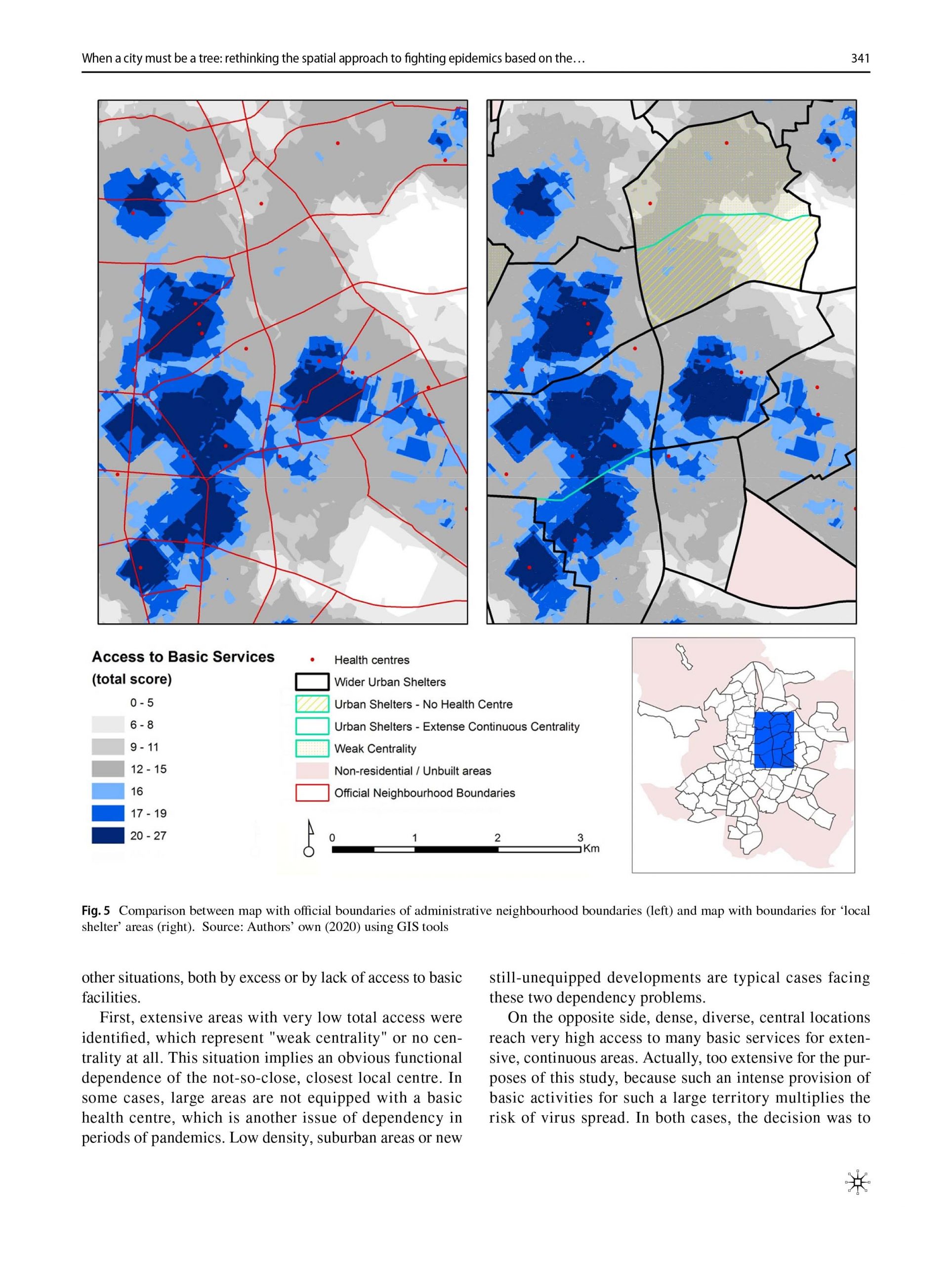
Carpio-Pinedo, J., Pozo Menendez, E., Lamiquiz Dauden, F. J., & Higueras Garcia, E. (2021). When a city must be a tree: rethinking the spatial approach to fighting epidemics based on the notion of ‘intermediate confinement’. Urban Design International, 1-16. https://doi.org/10.1057/s41289-021-00160-y
Principles of sustainability defend compactness, density and diversity as main characteristics of the optimal development of cities. These factors support public transport efficiency, economic activity, accessibility to equipments and services, proximity and walkability of streets and social exchanges in open public spaces. The Covid-19 pandemic crisis has called into question these factors perceived as booster of infections. However, dense and compact cities can also be the synonym of a more efficient provision of services, along with solidarity networks and creative solutions to fight the sanitary and economic crisis. Based on Alexander’s (1965) concepts of ‘tree’ and ‘semi-lattice’, this study aims to identify areas in the urban tissue that could be self-sufficient, that is functionally autonomous to manage epidemics from the neighbourhood scale. Encouraging healthier lifestyles during lockdown is fundamental for social resilience. What alternative spatial approach to fighting epidemics could perform better? How could an “intermediate confinement” based on self-sufficiency and the promotion of healthier environments become a major priority for action? The analysis of Madrid (Spain) offers a suitable case study due to its density, diversity and high contagiousness during the Covid-19 crisis, revealing also some issues to apply such ‘intermediate confinement’ strategy, due to major spatial imbalances.
Carpio-Pinedo, J. (2021). Multimodal transport and potential encounters with social difference: A novel approach based on network analysis. Journal of Urban Affairs, 43(1), 93-116. https://doi.org/10.1080/07352166.2019.1662727
Direct experience of social difference is crucial if lower levels of prejudice and greater social cohesion are to be achieved in our cities. Despite their key role of connecting places and people, transport infrastructures have scarcely been assessed as facilitators of encounters with social difference. Furthermore, urban contexts are progressively more complex due to the increasing relevance of transport multimodality along with the unequal degree of access to different transport modes. Building upon network analysis and consolidated accessibility measures, this study presents multi-accessibility as a concept and quantitative instrument to evaluate the potential encounter of difference in city spaces opened up by multimodal transport infrastructures. Multi-accessibility is also presented as a relevant and complementary policy avenue to enhancing social cohesion through transport planning and land use policies in the future. Two planning scenarios for the case of the Madrid metropolitan area illustrate the application, utility and interpretability of the instrument.
López-Lambas, M. E., Sánchez, J. M., & Alonso, A. (2021). The walking health: A route choice model to analyze the street factors enhancing active mobility. Journal of Transport & Health, 22, 101133. https://doi.org/10.1016/j.jth.2021.101133
Introduction. The promotion of walking for transportation is a promising strategy to address not only the traffic bottlenecks or environmental pollution but also to provide health benefits to the patrons. Nevertheless, as enhancing active modes of transportation, including trips to and from shops-is easier in small or medium cities, it is quite a complex task in big urban areas.
Methods. In the framework of the R + D + i DESPACIO project, in 2018, a street and online survey was carried out in the city of Madrid to gather information about different mobility habits, focusing on pedestrian mobility and on the respondents’ perceptions of issues related to mobility on foot. In order to promote more trips on foot, this study analyzed the factors influencing the walking route choice, other than distance. Some respondents also drew on a map the routes undertaken the previous day, indicating the trip purpose. Using the TransCAD software, the real factors that influenced the respondents when walking were obtained.
Results. The key factors for selecting the walking routes were those linked to attractiveness (e.g., green areas, amenities, tourist attractions, etc.) and accessibility (e.g., obstacles, pavement width). The purpose of the trip did not change much the results, although they were accentuated when the trips were made for shopping.
Conclusions. The applied methodology confirms that pedestrian streets, with green areas or access facility —and, hence, less noisy and polluted — were those enhancing a walking habit, and they were also the ones preferred by the citizens, who appreciated those attributes above the more classic ones of distance and time. Therefore, the street design and the pedestrian routes were found to be the most suitable to achieve healthier cities and citizens.
2019
Carpio-Pinedo, J., De Gregorio Hurtado, S., & Sánchez De Madariaga, I. (2019). Gender mainstreaming in urban planning: the potential of geographic information systems and open data sources. Planning Theory & Practice, 20(2), 221-240. https://doi.org/10.1080/14649357.2019.1598567
While gender mainstreaming has become a key principle for fostering equality across all fields of policy, actual implementation in the field of urban planning is still underdeveloped. We posit that Geographic Information Systems (GIS) and open data sources can and should be useful tools that effectively contribute to devising more effective ways of implementing a gender-sensitive agenda in urban planning. We take the case of Madrid to illustrate how these tools can contribute to gender mainstreaming in planning by building a methodology based on the concepts of infrastructures for everyday life and the perception of safety.
2015
Pinedo, J. C., & Daudén, P. J. L. (2015). Proximidad del comercio e indicadores de accesibilidad: aplicación a la planificación y regulación en el marco normativo actual. Ciudades, (18), 217-237. https://doi.org/10.24197/ciudades.18.2015.217-237
El comercio en entornos de proximidad es un servicio básico para la población, con múltiples implicaciones para la ciudad, la vitalidad del espacio público y la equidad social. Este trabajo indaga sobre las posibilidades del concepto y las medidas de accesibilidad, para, en el actual marco normativo que regula la actividad comercial, poder llegar a construir indicadores cuantitativos que sirvan para la protección y fomento del comercio en entornos de proximidad. Para ello, se analiza el encaje del concepto de accesibilidad dentro de las “razones imperiosas de interés general”, las únicas que permite invocar la Directiva Europea 123/2006 “Bolkestein”. A continuación se valoran diversas propuestas de indicadores para el caso comercial, de objetivos y aproximaciones diversas, proponiéndose un marco de análisis basado en su utilidad y precisión, así como su potencial para la planificación y normativa urbanístico-comercial.
Libros
Lamíquiz Daudén, Francisco José; Baquero Larriva, María Teresa; Orozco Salinas, Karina, Editors (2024). “Book of Abstract. Proximity Planning International Congress” UPM. ISBN 978-84-09-63887-1.

The International Congress on Proximity Planning (June 26 – 28, 2024) has presented original research papers that explore the thematic and empirical challenges and opportunities that arise in the application of proximity-based planning in cities.
Proximity is a planning principle with a tradition of more than a century, recently revived by circumstances such as COVID-19 and the impact of ITs, or by urban strategies such as the 15-minute city in Paris, the superblocks in Barcelona, or the blocks of care in Bogota. The current opportunity is to promote proximity as one of the foundations of urban regeneration processes to meet global challenges. However, the conceptual framework in which to integrate it, its policies, tools and metrics among other questions, need further discussion. Thus, the abstracts presented addressed, but not limited to, the following areas:
| Frameworks | 15-minute city & Proximity-Centered Accessibility. Healthy City. Walkable City. Equity & gender. Mobility justice.
| Challenges 1 | Urban regeneration. Affordable housing and re-densification. Peripheral centralities. Local economy. Proximity agriculture.
| Challenges 2 | Territorial and medium distance mobilities (public transport, bikes & micromobility). Commuting to work.
| Challenges 3 | Proximity planning across city scales. Urban-rural relationships, service proximity in rural environments.
| Tools 1 | Policy & planning tools for proximity. Public participation. Digitalization.
| Tools 2 | Accessibility metrics.
Proximity planning encompasses a diverse range of disciplines seeking to promote equitable accessibility in support of complete neighborhoods. A complete neighborhood offers destinations and activities that support the daily life of residents and visitors. But it is not only about destinations. From housing, urban design, and infrastructure, to planning tools, resource allocation, and social interaction, understanding that the dynamics of proximity planning hold immense potential for re-creating sustainable and well-functioning cities.
I. CREDITS
II. CONTENT AND RESULTS
III. ABSTRACTS
PARALLEL SESSIONS A
PARALLEL SESSIONS B
PARALLEL SESSIONS C
PARALLEL SESSIONS D
- Molina, Victor
- Shirazi, Zahra
- Sahasrabudhe, Sanika
- Bhonsle, Pratapsingh
- Porto Schettino, Mateus
- Espinosa Sánchez, Eduardo
- González González, Francisco Javier
- Carpio Pinedo, José
- Moreno Sanz, Joan
- Travesí Marías, Carolina
- Morán Alonso, Nerea
- Rivera Cruz, David
- Simón-Rojo, Marian
- Khurana, Shreya
- Higueras García, Esther
- Román López, Emilia
- Rey, Silvia
- Arenas, Sergio
- Pozo Menéndez, Elisa
- Rodriguez, Erwin
- Sousa, Nuno
- Castro Neto, Miguel de
- Jardim, Bruno
- Barriguinha, André
- Messa, Federico
- Raipat, Vaidehi
- Presicce, Dante
- Rofín Serrà, Marta
- Van Herk, Sebastiaan
- Gow McLenachan, Ruth
- Haye, Amber de la
- García Albertos, Celia
- Aivalioti, Sofia
- Ball, Caitlin
- Ceccarelli, Giulia
- Londoño, Ana María
- Fukuda, Simone
- Bazzoni, Filippo
- Gorrini, Andrea
- Adorean, Cristian Emanuel
- Nofre, Jordi
- García Juan, Laura
- Moura, Filipe
- Gerten, Christian
- Groth, Sören
- Coello Salcedo, Mateo
- Zhunio Pelaez, Andrés
- Chalhoub Dourado, Guilherme
- Hermida Palacios, Carla
- Buse Bingöl, Hatice
- Heinen, Eva
- Grindlay Moreno, Alejandro L.
- Molero Melgarejo, Emilio
- Lizárraga Mollinedo, Carmen
- Özçelik, Zehra
- Condo Bautista, José Rafael
- Serpa Bustamante, Yesenia Guillermina
- Correa Barahona, Diego Estuardo
- Nello Deakin, Samuel
- Sila Akinci, Zeynep
- Sancho Vallvé, Candela
- Öykü Türken, Araf
- Al Mujtabe, Abdullah
- Islam, Ishrat
- Sanz Alduán, Alfonso
- López, Penélope
- Amo, Javier del
- Sánchez, José Ignacio
- Jiménez Martín, Delfín
- Ramírez Sáiz, Alba
- Kiliç, İlayda
- Kerem Koramaz, Turgay
- Schultheiss, Marc Edouard
- Rodriguez Illanes, Alba
- López Parejo, Alejandro
- García Campo, Laura
- Gutiérrez Redondo, Ismael
- Lamíquiz Daudén, Francisco José
- Blanco Fernández, Nuria
- Rodriguez, Daniel
- Baquero Larriva, María Teresa
- Seisenberg, Sebastian
- Büttner, Benjamin
- Alpalhão, Nuno
- Borini, Martina
- Soukhov, Anastasia
- Soria Lara, Julio Alberto
- Paez, Antonio
- Paulusová, Ivana
- Sharmeen, Fariya
- Benito Moreno, Manuel
- Martínez Rico, Beatriz
- Albashir, Abubakr
- Tyler, Nick
- Pedrazzoli, Alessandro
- Marigil, Carlos
- Romanillos Arroyo, Gustavo
- Bhardwaj, Akanksha
- Jain, Deepty
- Khorramisarvestani, Sepideh
- Eicker, Úrsula
- Abdelfattah, Lamia
- Choubassi, Rawad
- Scarponi, Lily
- Valenzuela, Catalina
- Carpentieri, Gerardo
- Gargiulo, Carmela
- Guida, Carmen
- Martinelli, Valerio
- Stiuso, Tonia
- Zucaro, Floriana
- Andreola, Florencia
- Da Re, Laura
- Muzzonigro, Azzurra
- Cañas, Carlos
- Gargiulo, Eleonora
- Walker, Jim
- Busse, Jana
- Künbet, Seray
- Dehler, Katharina
- Knese, Dennis
- Calderon, Francisco
- Orellana, Daniel
- Carrasco, María Isabel
- Astudillo, Johnatan
- Hermida, María Augusta
- L’Hostis, Alain
- Aïta Cissé, Ndèye
- Hachette, Maxime
- Plastara, Dimitra
- Pozoukidou, Georgia
- Vecchio, Giovanni
- Rico Pinazo, Pablo
- Navas Vela, María Cristina
- Navas Carrillo, Daniel
- Márquez Ballesteros, María José
- Meza Parra, Sandra K.
- Arellano Ramos, Blanca
- Roca Cladera, Josep
- Fernández-Áñez, María Victoria
- Alfaro Anguita, Francisco
- Fernández Usón, José Antonio
- Álvarez de Tomás, Javier
- Farnood, Ahad
- Cucuzzella, Carmela
- Liu, Yage
- Oberman, Job
- Beukers, Els
- Sanz dos Santos Thomé, Luiza
- Pineda Fernández de Córdova, Caridad
- Bernal Reino, Elisa
- Chatman, Daniel
- Moya Gómez, Borja
- Orrego Oñate, Jaime
- Wu, Peiling
- Engström, Emma
- Sharmeen, Fariya
- Villalba Ortiz, Aida
- Carot Sierra, Jose Miguel
- Brownrigg Gleeson, Mari Luz
- López Carreiro, Iria
- Monzón de Cáceres, Andrés
- Vukmirovic, Milena
- Waidler, Melanie
- Schumann, Hans-Heinrich
- Morton, Craig
- Kamoun, Cyrine
- Duran Rodas, David
- Bouallala, Wafae
- Castaño Herrera, Daniela
- Gutiérrez Velandia, Andrea
- Ribeiro da Silva, Pedro
- Teles, Paula
- Cerullo, Cipriano
- Losco, Salvatore
- Malo de Molina Bodelón, Javier
- Zazo Moratalla, Ana
- Orellana McBride, Alejandro
- Urda Peña, Lucila
- Eslava Cabanellas, Clara
- Gören Soares, Berfu Güley
- Santinha, Gonçalo
- Mahé Duque, Catalina
- Vergel Tovar, Erik
- Gartmeier, Helena
- Loder, Allister
- Nektarios Koulouris, Spyridon
- Lunardon, Alice
- Ruf, Stefanie
- Valenzuela Montes, Luis Miguel
- Gázquez Martínez, Francisco Javier
- Arias Molinares, Daniela
- Talavera Garcia, Rubén
- Garcia Palomares, Juan Carlos
- Moreno Alba, Daniel
- Lang, Morin
- Contreras, Sebastián
- Espinoza, Fabian
- Cancino López, Jorge
- Pino Zúñiga, Johanna
- Yang, Yitao
Editors
Patxi J. Lamíquiz-Daudén | Universidad Politécnica de Madrid
María Teresa Baquero Larriva | Universidad Politécnica de Madrid
Karina Orozco Salinas | Universidad Politécnica de Madrid
Layout, editing and design
Karina Orozco Salinas | Universidad Politécnica de Madrid
Nuria Blanco Fernández | Universidad Politécnica de Madrid
Cover design
Melanie Waidler | Universidad Politécnica de Madrid
- Editors
- Patxi J. Lamíquiz-Daudén | Universidad Politécnica de Madrid
María Teresa Baquero Larriva | Universidad Politécnica de Madrid
Karina Orozco Salinas | Universidad Politécnica de Madrid
Layout, editing and design
Karina Orozco Salinas | Universidad Politécnica de Madrid
Nuria Blanco Fernández | Universidad Politécnica de Madrid
- ISBN: 978-84-09-63887-1
DOI: https://doi.org/10.20868/UPM.book.82998 - DEPOSITADO: 01/08/2024
DUyOT. Universidad Politécnica de Madrid,
Madrid, 26-28 de junio de 2024.
En la actualidad, con el conjunto del planeta amenazado por el calentamiento global, las ventajas de la marcha a pie en las ciudades aparecen más nítidas que nunca y tienen que ver con su mayor sostenibilidad ambiental frente a otros modos, pero comprenden también aspectos económicos, sociales y de salud.
El objetivo de esta guía es ofrecer al lector análisis, argumentos y recomendaciones para una mejor consideración de los peatones en el planeamiento urbanístico y en los proyectos arquitectónicos. Se trata de una exposición razonada de aquellos elementos urbanísticos y arquitectónicos susceptibles de incidir en la movilidad peatonal, que demuestra la importancia de la integración de ésta en la concepción y diseño urbano-arquitectónico.
Para permitir lecturas con diferentes niveles de profundidad, la guía ofrece distintos soportes de información: además del texto principal, las ilustraciones y respectivos pies, que permiten una lectura rápida al resumir e ilustrar los argumentos principales; las recomendaciones, al final de cada capítulo, con las conclusiones prácticas más relevantes; los recuadros que describen brevemente planes y proyectos españoles e internacionales; y el anejo, “Síntesis de los resultados del proyecto de investigación” que junto con las citas a pie de página dejan ver el sustrato científico del libro.
1. Introducción
2. Movilidad peatonal y rasgos urbanos
3. Consideración de los peatones en los planes urbanísticos municipales
4. Consideración de los peatones en los planes parciales o de área
5. La consideración de los peatones en los proyectos de arquitectura
Anejo. Resultados del proyecto de investigación
Julio Pozueta Echavarri (Dir.)
Francisco José Lamíquiz Daudén
Mateus Porto Schettino
Editorial
Centro de Estudios y Experimentación de Obras Públicas – CEDEX (Ministerio de Fomento, Gobierno de España)
Depósito legal e ISBN/ISSN
ISBN: 978-84-7790-509-7
Depósito Legal: M-48504-2009
NIPO: 163-09-045-X
Impresor
Artegraf S.A.
CAPÍTULOS DE Libros
Francisco José Lamiquiz Daudén (2023). Los retos de la movilidad urbana y la necesaria transformación de las calles de Madrid. En AA.VV. “Madrid, medio siglo de desarrollo Urbano (1973-2023)” Instituto de Estudios Madrileños – CSIC. (pp. 229 – 242).

“Durante diez semanas consecutivas, entre los meses de septiembre y noviembre de 2023, el Instituto de Estudios Madrileños (IEM) ha organizado en colaboración con el Colegio Oficial de Arquitectos de Madrid (COAM) el ciclo de conferencias Madrid, medio siglo de desarrollo urbano (1973-2023). Compuesto por cinco conferencias y cinco mesas redondas ha reunido a miembros del Instituto de Estudios Madrileños, responsables de algunas áreas municipales, arquitectos, catedráticos y profesionales cualificados para analizar cuál ha sido la evolución de la ciudad de Madrid en campos tan relevantes como la sociología, el urbanismo, el medio ambiente, la movilidad o la cultura. Fruto del convenio firmado en 2022 entre el Colegio Oficial de Arquitectos de Madrid y el Instituto de Estudios Madrileños, las conferencias y mesas redondas han tenido lugar en el Auditorio del COAM y han sido seguidas por unas 2.000 personas entre aquellos que acudieron presencialmente y quienes las siguieron por streaming en la página del COAM o, posteriormente, en el canal de YouTube del Instituto” (pág. 9).
[…]
La mesa redonda Cómo debe ser la movilidad urbana en el siglo XXI, moderada por Pedro Montoliú, reunió a Francisco de Borja Carabante, delegado del Área de Urbanismo, Medio Ambiente y Movilidad del Ayuntamiento de Madrid; Patxi J. Lamíquiz, profesor del Departamento de Urbanismo y Ordenación del Territorio de la Universidad Politécnica de Madrid; y Rocío Cascajo, doctora ingeniera de Montes y gerente técnico de INECO (Ingeniería y Economía del Transporte). Los ponentes analizaron las causas por las que ha cambiado la movilidad, la evolución de la demanda del transporte público, el impacto de las zonas de bajas emisiones, el papel del transporte público y de la logística, la integración de los distintos modos de transporte, el efecto en la movilidad de la innovación tecnológica, el reto que van a suponer el cambio climático y el aumento de la población mayor o cómo deben adaptarse las calles en el futuro” (pág. 11).
1. Sociología
2. Urbanismo
3. Movilidad
Los retos de la movilidad urbana y la necesaria
transformación de las calles de Madrid
Patxi J. Lamíquiz Daudén………………………………………… 229
4. Cultura
Autores: María Teresa Fernández Talaya y Pedro Montoliú
Créditos:
INSTITUTO DE ESTUDIOS MADRILEÑOS
Consejo Superior de Investigaciones Científicas
Centro de Ciencias Humanas y Sociales
Edición de los textos: Carlos Saguar Quer
©2023 Instituto de Estudios Madrileños
©2023 Los autores de las conferencias
ISBN: 978-84-126613-3-0
Depósito Legal: M-35974-2023
Diseño Gráfico: Francisco Martínez Canales
Impresión: Service Point Impreso en España
INSTITUTO DE ESTUDIOS MADRILEÑOS MADRID, 2023
Patxi J. Lamíquiz Daudén (2023) Movilidad sostenible, Cronourbanismo y Ciudad histórica, en Pedro Górgolas Martín & Victoriano Sainz Gutiérrez, Editores: “LA PLANIFICACIÓN URBANÍSTICA DE CONJUNTOS URBANOS HISTÓRICOS”. COA de Cádiz y Universidad de Cádiz.

AUA02.23 CURSO DE FORMACIÓN PERMANENTE `ONLINE´ LA PLANIFICACIÓN URBANÍSTICA DE CONJUNTOS URBANOS HISTÓRICOS
OBJETIVOS
Estudio del instrumento de ordenación urbanística detallada regulado en la actual legislación andaluza (Ley de Impulso a la Sostenibilidad del Territorio Andaluz) con la finalidad de adquirir un conocimiento básico sobre las principales técnicas instrumentales a aplicar.
PROGRAMA
JORNADA 01
SESIÓN DE MAÑANA
BASES CONCEPTUALES PARA EL PROYECTO DE LA CIUDAD HISTÓRICA
SESIÓN DE TARDE
FORO DE DEBATE
JORNADA 02
SESIÓN DE MAÑANA
BASES CONCEPTUALES PARA EL PROYECTO DE LA CIUDAD HISTÓRICA II
SESIÓN DE TARDE
FORO DE DEBATE
JORNADA 03
SESIÓN DE MAÑANA
LA PLANIFICACIÓN DE CIUDADES HISTÓRICAS: EXPERIENCIAS COMPARADAS
SESIÓN DE TARDE
PRÁCTICAS TUTELADAS
JORNADA 04
SESIÓN DE MAÑANA
LA PLANIFICACIÓN URBANÍSTICA DE CONJUNTOS HISTÓRICOS: PLANEAMIENTO ESPECIAL Y CATÁLOGOS
SESIÓN DE TARDE
PRÁCTICAS TUTELADAS
JORNADA 05
SESIÓN DE MAÑANA
PRÁCTICAS TUTELADAS PRESENCIALES
Estructura Docente
Clases Teóricas: streaming
Prácticas Tuteladas: streaming y presencial
Fechas
12, 19, 26 de mayo / 2 y 8 de junio 2023
Lugar
AULA VIRTUAL
PROFESORADO
Iban DÍAZ PARRA. Dr. en Geografía y graduado en Antropología. Profesor Titular del Departamento de Geografía Humana de la US. Director de dos proyectos de investigación sobre procesos de turistificación en grandes ciudades andaluzas.
Arsenio VILLAR LAMA. Dr. en Geografía. Profesor Titular del Departamento de Geografía Física y Análisis Geográfico Regional de la US. David LÓPEZ CASADO. Dr. en Geografía. Profesor interino del Departamento de Geografía Humana de la US.
Patxi J. LAMÍQUIZ DAUDÉN. Dr. Arquitecto. Profesor Contratado Doctor del Departamento de Urbanística y Ordenación del Territorio de la UPM. Experto en planificación urbana, espacio público y movilidad sostenible.
Sebastián JORNET FORNER Arquitecto. Profesor Asociado del Departamento de Urbanismo y Ordenación del Territorio de la UPC. Premio Nacional de Urbanismo (2006) y Premio Europeo de Urbanismo (2010).
Inés ESTEVE SEBASTIÁ. Arquitecta. Máster de Conservación del Patrimonio Arquitectónico. Redactora de numerosos trabajos urbanístico-patrimoniales.
Vicente CALABUIG MONTESINOS. Arquitecto. Máster de Conservación del Patrimonio Arquitectónico. Redactor de numerosos trabajos urbanístico-patrimoniales.
Juan Manuel BECERRA GARCÍA. Dr. Arquitecto. Máster en arquitectura y patrimonio histórico y académico correspondiente de la Real Academia de Nobles Artes de Antequera. Dirige el Servicio de Protección del Patrimonio Histórico de la Dirección General de Patrimonio Histórico y Documental de la Junta de Andalucía.
María Teresa PÉREZ CANO. Dra. Arquitecta. Catedrática del Departamento de Urbanística y Ordenación del Territorio de la ETSA US. Su labor investigadora ha estado centrada en el estudio del patrimonio cultural andaluz.
Profesor Tutor de la Práctica Manuel Ángel GONZÁLEZ FUSTEGUERAS. Arquitecto. Coordinador y Director del Equipo de la consultora Territorio y Ciudad SLP.
AULA UNIVERSITARIA DE ARQUITECTURA
Universidad de Cádiz
Colegio de Arquitectos de Cádiz
AUA02.23 CURSO DE FORMACIÓN PERMANENTE `ONLINE´ LA PLANIFICACIÓN URBANÍSTICA DE CONJUNTOS URBANOS HISTÓRICOS mayo – junio 2023
AULA UNIVERSITARIA DE ARQUITECTURA
Universidad de Cádiz
Colegio de Arquitectos de Cádiz
OTRAS PUBLICACIONES | material divulgativo

Patxi Lamíquiz Daudén. “La ciudad de proximidad: conversación con Patxi Lamíquiz” Podcast “El secreto de las ciudades” 19/9/2024, 29’11’’ https://www.ivoox.com/ciudad-proximidad-conversacion-patxi-lamiquiz-audios-mp3_rf_133963101_1.html
Descripción de la ciudad de proximidad: conversación con Patxi Lamíquiz
Este episodio se dedica a observar las cualidades que debe tener una ciudad de proximidad, con el profesor Francisco Lamíquiz Daudén, del Departamento de Urbanística y Ordenación del Territorio de la ETSAM (Universidad Politécnica de Madrid), experto en movilidad sostenible.

María Teresa Baquero, Patxi Lamíquiz Daudén. ¿Ciudades de proximidad y ciclables para luchar contra el cambio climático?. Published on junio 13 2024. The Conversation. Available at: https://theconversation.com/ciudades-de-proximidad-y-ciclables-para-luchar-contra-el-cambio-climatico-230250
El artículo refiere a la propuesta de la “ciudad de 15 minutos”, un modelo urbano que busca crear un entorno a escala humana donde las personas puedan acceder a sus actividades diarias en menos de 15 minutos a pie o en bicicleta. Este enfoque aspira a enfrentar retos contemporáneos como la desigualdad social, el envejecimiento de la población y el cambio climático, promoviendo la cohesión social y la accesibilidad para todos los grupos de la sociedad.
Entre los desafíos identificados, se destaca la necesidad de garantizar el acceso equitativo a servicios esenciales y la inclusión de todos los ciudadanos en la vida social. La planificación urbana tradicional ha perpetuado desigualdades y ha fomentado un uso excesivo del automóvil, lo que ha generado problemas ambientales y sociales, incluyendo la exclusión y la soledad no deseada. La pandemia ha acelerado el uso de servicios digitales, lo que plantea la posibilidad de integrar tecnología y diseño urbano para mejorar la calidad de vida.
Sin embargo, el modelo ha recibido críticas, como el riesgo de aumentar la segregación socioespacial y la especulación inmobiliaria, así como preocupaciones sobre la restricción de libertades individuales. A pesar de estas críticas, el artículo resalta beneficios comprobados del modelo, como la reducción de la inseguridad y el fomento de la actividad económica local, al recuperar tiempo de desplazamiento para mejorar la vida social y familiar.
La ciudad de 15 minutos se presenta como una oportunidad para abordar las necesidades de los grupos desfavorecidos, aunque su implementación deberá ser adaptada a las particularidades de cada contexto. En resumen, este enfoque busca construir ciudades más inclusivas y sostenibles, donde todos sus habitantes puedan disfrutar de un espacio accesible.

Patxi Lamíquiz Daudén (2024) “ La ciudad debe ofrecer servicios a los mayores y redes de apoyo a una distancia caminable” Revista Entremayores 204, mayo 2024 https://entremayores.es/a-fondo-complementaria/la-ciudad-debe-ofrecer-servicios-a-los-mayores-y-redes-de-apoyo-a-una-distancia-caminable/
“La ciudad debe ofrecer servicios a los mayores y redes de apoyo a una distancia caminable.”
Entrevista a Patxi Lamíquiz sobre el enfoque de proximidad, quien destaca que: “Nuestras viviendas deben adaptarse y hacerse accesibles; las calles, igualmente, deben ser accesibles para todos.”

María Teresa Baquero, Patxi Lamíquiz Daudén. Un sitio para mayores, niños y personas con discapacidad en la ciudad de 15 minutos. Published on november 7th 2023. The Conversation. Available at: https://theconversation.com/un-sitio-para-mayores-ninos-y-personas-con-discapacidad-en-la-ciudad-de-15-minutos-216679
La publicación destaca la creciente importancia de diseñar ciudades accesibles y seguras para todos, especialmente ante el aumento previsto de la población mayor y el crecimiento de las áreas urbanas. En 2050, se estima que el número de personas mayores de 65 años se duplicará, lo que plantea desafíos para la calidad de vida en entornos urbanos. La pandemia de COVID-19 ha enfatizado la necesidad de un entorno urbano que favorezca la salud y el bienestar de los habitantes.
El artículo subraya la urgencia de considerar a los grupos más vulnerables, como personas con discapacidad, ancianos y niños, en el diseño de espacios públicos. Se señala que el 16% de la población mundial experimenta alguna forma de discapacidad, y que eliminar barreras arquitectónicas y de transporte es fundamental para promover la inclusión, un concepto conocido como diseño universal.
Además, se aborda el envejecimiento y sus efectos en las capacidades físicas y mentales, así como los riesgos de accidentes en entornos urbanos para personas mayores y niños. Se proponen soluciones que busquen garantizar la seguridad y bienestar de todos los ciudadanos, fomentando un entorno urbano que priorice la accesibilidad y la inclusión.

María Teresa Baquero, Patxi Lamíquiz Daudén. ¿Por qué la ciudad de 15 minutos? Hacia una mayor igualdad y cohesión social. Published on september 19th 2023. The Conversation. Available at: https://theconversation.com/por-que-la-ciudad-de-15-minutos-hacia-una-mayor-igualdad-y-cohesion-social-206106
El artículo refiere a la propuesta de la “ciudad de 15 minutos” de París, un modelo urbano que busca crear un entorno a escala humana donde las personas puedan acceder a sus actividades diarias en menos de 15 minutos a pie o en bicicleta. Este enfoque aspira a enfrentar retos contemporáneos como la desigualdad social, el envejecimiento de la población y el cambio climático, promoviendo la cohesión social y la accesibilidad para todos los grupos de la sociedad.
Entre los desafíos identificados, se destaca la necesidad de garantizar el acceso equitativo a servicios esenciales y la inclusión de todos los ciudadanos en la vida social. La planificación urbana tradicional ha perpetuado desigualdades y ha fomentado un uso excesivo del automóvil, lo que ha generado problemas ambientales y sociales, incluyendo la exclusión y la soledad no deseada. La pandemia ha acelerado el uso de servicios digitales, lo que plantea la posibilidad de integrar tecnología y diseño urbano para mejorar la calidad de vida.
Sin embargo, el modelo ha recibido críticas, como el riesgo de aumentar la segregación socioespacial y la especulación inmobiliaria, así como preocupaciones sobre la restricción de libertades individuales. A pesar de estas críticas, el artículo resalta beneficios comprobados del modelo, como la reducción de la inseguridad y el fomento de la actividad económica local, al recuperar tiempo de desplazamiento para mejorar la vida social y familiar.
La ciudad de 15 minutos se presenta como una oportunidad para abordar las necesidades de los grupos desfavorecidos, aunque su implementación deberá ser adaptada a las particularidades de cada contexto. En resumen, este enfoque busca construir ciudades más inclusivas y sostenibles, donde todos sus habitantes puedan disfrutar de un espacio accesible.

Patxi Lamíquiz Daudén (2023) La ciudad de 15 minutos. Equipamiento y Servicios Municipales, 204. https://www.eysmunicipales.es/revista/segundo-trimestre-c1
El artículo aborda la creciente desconexión física en un mundo cada vez más digitalizado, especialmente en ciudades que enfrentan problemas de movilidad y un impacto ambiental significativo. En respuesta a la emergencia climática y la insalubridad urbana, se sugiere replantear la planificación urbana mediante modelos de proximidad, que buscan reducir la huella ambiental y recuperar la cercanía humana.
Para explorar cómo estas iniciativas están cambiando el funcionamiento de las ciudades y la forma en que se conciben nuestras comunidades, se recurre a la visión de dos expertos en la materia. Por un lado, Carlos Moreno, investigador de renombre internacional, profesor asociado en la Universidad de París IAE-Panteón Sorbona en Francia, cofundador y director científico de la cátedra ETI “Emprendimiento-Territorio-Innovación”, y creador del concepto “ciudad de 15 minutos”; por otro, Patxi Lamíquiz Daudén, profesor contratado doctor del Departamento de Urbanismo y Ordenación del Territorio en la Escuela Técnica Superior de Arquitectura de Madrid de la Universidad Politécnica de Madrid, y director de la iniciativa Planificando Proximidad o Proximity Planning, que investiga la genealogía de la ciudad de proximidad y sus casos de éxito.