Advanced geomatics, air quality and carbon footprint
Our research primarily focuses on developing and applying advanced geospatial technologies and machine learning models for environmental and urban monitoring, particularly in vulnerable and data-scarce regions. Core activities involve using Multi-Temporal Interferometric Synthetic Aperture Radar (MT-InSAR) and Persistent Scatterer Interferometry (PSI) with satellite data (e.g., ERS, Envisat, Sentinel-1) to detect and analyze ground deformation. This includes monitoring groundwater levels, aquifer storage, and land subsidence caused by over-extraction in urban areas like Madrid and Guatemala City.
Beyond subsidence, we apply MT-InSAR for dam monitoring, in particular to assess the stability and deformation of structures and their basins. We use machine learning for urban image analysis, including automatic building height estimation from street-view imagery for seismic exposure assessment in places like San José, Costa Rica. Furthermore, we employ transformer-based models and aerial imagery for mapping urban infrastructure (e.g., parking, roads, sidewalks) and for analyzing temporal trends in cities like Madrid and Vienna. We use Sentinel-1 and Sentinel-2 time series for land cover classification, especially in forest-agriculture mosaics.
Another line of work is environmental sustainability assessment and climate change mitigation. Our work spans diverse domains, including the carbon footprint and socio-economic impacts of Information and Communications Technology (ICT) networks, sustainability in public procurement and higher education, and carbon sequestration in both urban green infrastructure and natural forest ecosystems. We are also very active in air quality monitoring and urban environmental policy evaluation, leveraging the use of satellite data (Sentinel-5P TROPOMI) complemented by ground observations. We employ sophisticated tools like Multi-Regional Environmentally Extended Input-Output (MR-EEIO), the Compound Method based on Financial Accounts (MC3), and forest carbon models (CO2Fix) to provide comprehensive, data-driven insights for sustainable development and informed decision-making across various scales and sectors.
Recent interests and contributions
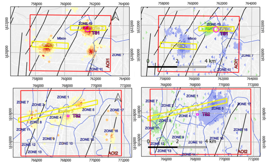
- Groundwater management and land subsidence monitoring. We use MT-InSAR and PSI to map groundwater levels, aquifer storage variations, and identify land subsidence caused by groundwater over-extraction. We have applied these satellite-based measurements to infer spatio-temporal evolution of water levels and quantify storage changes in aquifers (e.g. the Madrid aquifer). We have identified critical subsidence areas in the Metropolitan Region of Guatemala (MRG), correlating deformation patterns with intense groundwater exploitation and specific geological characteristics like alluvial and pyroclastic aquifers. Our research highlights the urgent need for sustainable water management and integrating MT-InSAR into monitoring schemes in vulnerable urban areas.
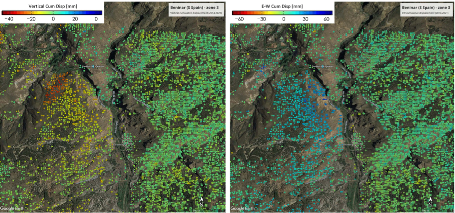
- Dam deformation monitoring. Our group contributes to the monitoring of earth-fill dams by integrating Multi Temporal InSAR (MT-InSAR) with dam modeling. We have successfully applied MT-InSAR to provide reliable and continuous monitoring of dam deformation, surpassing the precision of traditional systems. We applied this methodology to the Benínar dam in Spain. Our work confirms that MT-InSAR data are consistent with modeled consolidation of dams, showing decreased subsidence velocities over time. This approach also allows for integrated monitoring of the dam basin, including critical slopes and surrounding infrastructures. We advocate for the full integration of MT-InSAR and 3D modeling into dam safety management, complementing traditional geotechnical monitoring.
- Seismic exposure and building vulnerability assessment. We develop low-cost and scalable geospatial methodologies for assessing building seismic exposure. This is particularly important in data-scarce environments, like San José, Costa Rica. Our contributions include extracting key building attributes (e.g., footprint, height, plan regularity, construction date, roof material, urban block compactness) from open-access geospatial data using geomatic techniques. We also employ machine learning models, such as Random Forests, to classify buildings into expert-defined typologies. This approach improves classification accuracy when building height is included. We also apply semantic segmentation machine learning models to street-view imagery for automatic building height estimation, a crucial parameter for seismic vulnerability assessment.
- Urban infrastructure mapping and change detection. We integrate machine learning into urban aerial image analysis to identify mobility-related surfaces and analyze historical trends. We have developed a workflow for automatically generating geospatial datasets, training transformer-based models for semantic segmentation of features like parking spaces, road surfaces, and sidewalks. Our work in Madrid and Vienna demonstrates the method’s ability to uncover temporal infrastructure trends, revealing changes in parking surfaces, roads, and sidewalks over time. This may provide a cost-effective solution for municipal governments to gather valuable urban data and evaluate car usage in neighborhoods, supporting sustainable urban transport planning by identifying reallocations of urban space.
- Comprehensive carbon footprint assessment and sustainability metrics. We develop and apply robust methodologies, such as the Compound Method based on Financial Accounts (MC3) and Multi-Regional Environmentally Extended Input-Output (MR-EEIO), for holistic sustainability evaluations. We have quantified the carbon footprint and employment generation across diverse sectors, including the deployment of ICT networks (encompassing end-user devices, infrastructure, and energy), public services through Green Public Procurement, and university operations. Our work highlights the critical importance of Scope 3 emissions and indirect impacts for understanding true environmental burdens and for formulating effective carbon management plans and eco-innovation strategies.
- Air quality monitoring and urban pollution management. We have tested the effectiveness of urban environmental policies, such as Madrid’s Low Emission Zone (LEZ), on nitrogen dioxide (NO2) concentrations using advanced satellite data from Sentinel-5P TROPOMI. The satellite data is consistent with surface-level measurements. We have investigated the intricate influence of meteorological factors like wind speed, temperature, solar radiation, and ozone (O3) on NO2 dynamics in major Spanish cities, revealing distinct patterns in inland versus coastal environments. Our findings demonstrate the value of remote sensing for characterizing pollution distribution, identifying hotspots, and assessing policy impacts, notably during events like the COVID-19 pandemic.
Groups and laboratories
Topography and Geomatics Laboratory
Applied Advanced Geomatics Group
Scientific-technological services
Movement control of terrain and civil infrastructure using DInSAR remote sensing
3D Modeling in inverse engineering and cultural heritage
Life cycle analysis and carbon footprint of products and corporations
CIVILis researchers involved
Selected references
- Marta Béjar-Pizarro, Pablo Ezquerro, Gerardo Herrera, Roberto Tomás, Carolina Guardiola-Albert, José M. Ruiz Hernández, José A. Fernández Merodo, Miguel Marchamalo, Rubén Martínez. Mapping groundwater level and aquifer storage variations from InSAR measurements in the Madrid aquifer, Central Spain. Journal of Hydrology 547, 678–689, 2017. https://doi.org/10.1016/j.jhydrol.2017.02.011
- Miguel Ureña Pliego, Rubén Martínez Marín, Nianfang Shi, Takeru Shibayama, Ulrich Leth, Miguel Marchamalo Sacristán. Transport-related surface detection with machine learning: Analyzing temporal trends in Madrid and Vienna. Remote Sensing Applications: Society and Environment 37, 101503, 2025. https://doi.org/10.1016/j.rsase.2025.101503
- Miguel Ureña-Pliego, Rubén Martínez-Marín, Beatriz González-Rodrigo, Miguel Marchamalo-Sacristán. Automatic Building Height Estimation: Machine Learning Models for Urban Image Analysis. Appl. Sci. 13 (8), 5037, 2023. https://doi.org/10.3390/app13085037
- Javier Rodríguez-Saiz, Beatriz González-Rodrigo, Juan Gregorio Rejas-Ayuga, Diego A. Hidalgo-Leiva, Miguel Marchamalo-Sacristán. Assessing Building Seismic Exposure Using Geospatial Technologies in Data-Scarce Environments: Case Study of San José, Costa Rica. Appl. Sci. 15 (11), 6318, 2025. https://doi.org/10.3390/app15116318
- Audrey Mercier, Julie Betbeder, Florent Rumiano, Jacques Baudry, Valéry Gond, Lilian Blanc, Clément Bourgoin, Guillaume Cornu, Carlos Ciudad, Miguel Marchamalo, René Poccard-Chapuis, Laurence Hubert-Moy. Evaluation of Sentinel-1 and 2 Time Series for Land Cover Classification of Forest–Agriculture Mosaics in Temperate and Tropical Landscapes. Remote Sens. 11 (8), 979, 2019. https://doi.org/10.3390/rs11080979
- Miguel Marchamalo-Sacristán, Antonio Miguel Ruiz-Armenteros, Francisco Lamas-Fernández, Beatriz González-Rodrigo, Rubén Martínez-Marín, José Manuel Delgado-Blasco, Matus Bakon, Milan Lazecky, Daniele Perissin, Juraj Papco, Joaquim J. Sousa. MT-InSAR and Dam Modeling for the Comprehensive Monitoring of an Earth-Fill Dam: The Case of the Benínar Dam (Almería, Spain). Remote Sens. 15 (11), 2802, 2023. https://doi.org/10.3390/rs15112802
- Carlos García-Lanchares, Miguel Marchamalo-Sacristán, Alfredo Fernández-Landa, Candela Sancho, Vrinda Krishnakumar, Belén Benito. Analysis of Deformation Dynamics in Guatemala City Metropolitan Area Using Persistent Scatterer Interferometry. Remote Sens. 15 (17), 4207, 2023. https://doi.org/10.3390/rs15174207
- Carlos García-Lanchares, Alfredo Fernández-Landa, José Luis Armayor, Orlando Hernández-Rubio, Miguel Marchamalo-Sacristán. The Influence of Groundwater Management on Land Subsidence Patterns in the Metropolitan Region of Guatemala City: A Multi-Temporal InSAR Analysis. Remote Sens. 17 (9), 1496, 2025. https://doi.org/10.3390/rs17091496
- Guillermo San Miguel, Brigitte M. Bañales, Diego Ruiz, Sergio Álvarez, Jorge Pérez, María T. Arredondo. Carbon footprint and employment generation produced by ICT networks for Internet deployment: A multi-regional input-output analysis . Science of the Total Environment 914, 169776, 2024. https://doi.org/10.1016/j.scitotenv.2023.169776
- Sergio Alvarez, Marco Blanquer, Agustín Rubio. Carbon footprint using the Compound Method based on Financial Accounts. The case of the School of Forestry Engineering, Technical University of Madrid . Journal of Cleaner Production 66, 224–232, 2014. https://doi.org/10.1016/j.jclepro.2013.11.050
- Carlos Morillas, Sergio Alvarez, Jose C.M. Pires, Adrian Jesus Garcia, Sara Martinez. Impact of the implementation of Madrid’s low emission zone on NO2 concentration using Sentinel-5P/TROPOMI data . Atmospheric Environment 320, 120326, 2024. https://doi.org/10.1016/j.atmosenv.2024.120326
- Sergio Alvarez, Carlos Ortiz, Eugenio Díaz-Pinés, Agustín Rubio. Influence of tree species composition, thinning intensity and climate change on carbon sequestration in Mediterranean mountain forests: a case study using the CO2Fix model . Mitig Adapt Strateg Glob Change 21, 1045–1058, 2016. https://doi.org/10.1007/s11027-014-9565-4