
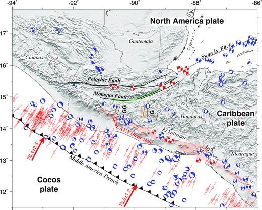
We describe a new elastic-kinematic model for the present tectonics of northern Central America and southern Mexico, where the Motagua-Polochic fault zone, Middle America subduction zone and faults in the Central America volcanic arc pose significant seismic hazards.
Categoría: Terremotos
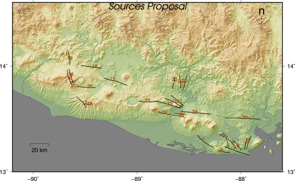
Main crustal seismic sources in El Salvador
We present a map and a data set containing information about intra-plate seismic sources in El Salvador. These are the results of the field campaigns and data analysis carried out by the research group of Planetary Geodinamics, Active Tectonics and Related Risks from Complutense University of Madrid during the last 12 years.

Approach for combining fault and area sources in seismic hazard assessment: application in south-eastern Spain
This paper presents a methodological approach to seismic hazard assessment based on a hybrid source model composed of faults as independent entities and zones containing residual seismicity. The seismic potential of both types of sources is derived from different data: for the zones, the recurrence model is estimated from the seismic catalogue. For fault sources, it is inferred from slip rates derived from palaeoseismicity and GNSS (Global Navigation Satellite System) measurements.

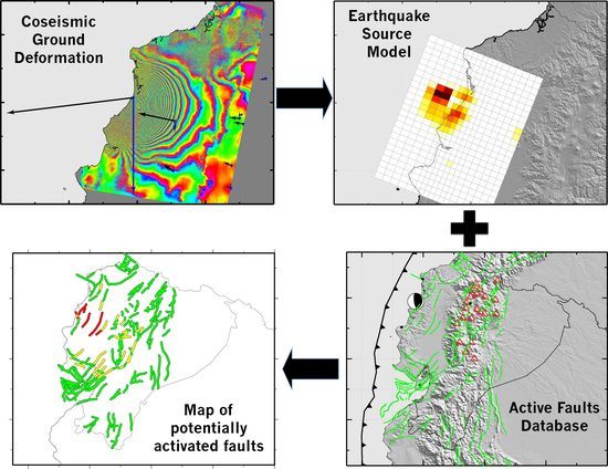
InSAR-Based Mapping to Support Decision-Making after an Earthquake
It has long been recognized that earthquakes change the stress in the upper crust around the fault rupture and can influence the behaviour of neighbouring faults and volcanoes. Rapid estimates of these stress changes can provide the authorities managing the post-disaster situation with valuable data to identify and monitor potential threads and to update the estimates of seismic and volcanic hazard in a region.
Analysis of the 2012 Ahar-Varzeghan (Iran) seismic sequence: Insights from statistical and stress transfer modeling
The 2012 Ahar-Varzeghan (Northwestern Iran) earthquake doublet and its following seismic sequence are analyzed in this paper. First, it is examined the time-varying statistical characteristics of seismic activity since the occurrence of the doublet (two large events with Mw = 6.4 and 6.2) that initiated the sequence on 11 August 2012.
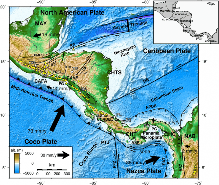
The new Central American seismic hazard zonation: Mutual consensus based on up to day seismotectonic framework.
Central America is one of the most active seismic zones in the World, due to the interaction of five tectonic plates (North America, Caribbean, Coco, Nazca and South America), and its internal deformation, which generates almost one destructive earthquakes (5.4 ≤ Mw ≤ 8.1) every year. A new seismological zonation for Central America is proposed based on seismotectonic framework, a geological context, geophysical and geodetic evidence, and previous works.

Present-day crustal deformation along the El Salvador Fault Zone from ZFESNet GPS network
This paper presents the results and conclusions obtained from new GPS data compiled along the El Salvador Fault Zone (ESFZ). We calculated a GPS-derived horizontal velocity field representing the present-day crustal deformation rates in the ESFZ based on the analysis of 30 GPS campaign stations of the ZFESNet network, measured over a 4.5 year period from 2007 to 2012.

Structural evolution of the El Salvador Fault Zone: an evolving fault system within a volcanic arc
The El Salvador Fault Zone, firstly identifiedafter the 13th February 2001 Mw 6.6 El Salvador earthquake, is a 150 km long,20 km wide right-lateral strike-slip fault system. Ruptures along the ESFZ arethought to be responsible for most of the historical destructive earthquakesalong the El Salvador Volcanic Arc, as well as for most of the currentseismicity of the area.
