
GPS constraints on deformation in northern Central America from 1999 to 2017, Part 2: Block rotations and fault slip rates, fault locking and distributed deformation
Ellis, A., DeMets, C., McCaffrey, R., Briole, P., Cosenza Muralles, B., Flores, O., Guzmán-Speziale, M., Hernández, D., Kostoglodov, V., LaFemina, P., Lord, N., Lasserre, C., Lyon-Caen,H., Rodriguez Maradiaga, M., Molina, E., Rivera, J., Rogers, R., Staller, A., Basil, T. (2019). GPS constraints on deformation in northern Central America from 1999 to 2017, Part 2: Block rotations and fault slip rates, fault locking and distributed deformation. Geophysical Journal International, 218(2), 729-754. DOI: 10.1093/gji/ggz173f
Abstract
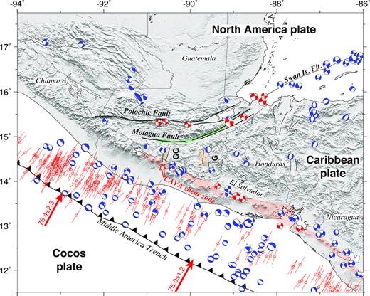
We describe a new elastic-kinematic model for the present tectonics of northern Central America and southern Mexico, where the Motagua-Polochic fault zone, Middle America subduction zone and faults in the Central America volcanic arc pose significant seismic hazards. The new model, which consists of the angular velocities for eight plates and blocks, interseismic locking solutions for some of the block-bounding faults and strain-rate tensors for three blocks with significant internal deformation, optimizes the fit to regional fault azimuths and earthquake slip directions and a new 200+ station GPS velocity field that has been corrected for the coseismic and post-seismic effects of three large regional earthquakes in 2009 and 2012. From our new observations and modelling thereof, we find evidence for the following: 13±1 mm yr−1 of ≈E-W stretching between undeformed Caribbean plate in central Honduras and a location ≈50 km west of the Guatemala City graben; accommodation of the above extension via slow W-to-WNW motions of newly defined Chortis and Ipala blocks and distributed ENE-WSW stretching within both blocks; 80 per cent of Chortis-North America plate motion in eastern Guatemala occurs on the Motagua fault versus only 20 per cent on the Polochic fault; Motagua fault slip rates that decrease westwards from 14 ± 1.5 mm yr−1 to 9–10 ± 2 mm yr−1 to less than 2 mm yr−1 in eastern Guatemala, central Guatemala and west of the Guatemala City graben, respectively; Slip rates along Central America volcanic arc faults that decrease from 12.5 ± 1.0 mm yr−1 in Nicaragua to 10 ± 1.3 mm yr−1 in central El Salvador to 7.6 ± 2.1 mm yr−1 on the Jalpatagua fault of southern Guatemala to 2-3 mm yr−1 or less across the volcanic arc west of Guatemala City; a transition near the Mexico–Guatemala border from moderate-to-high locking of the subduction interface offshore from southern Mexico to low locking below the Central America forearc sliver; Subduction of the Cocos plate beneath the Central America forearc sliver up to 10 mm yr−1 faster than and 7–8° clockwise from all previous estimates; 12 ± 6 mm yr−1 of E–W extension across the newly defined Fonseca block. A pattern of misfits to the velocities of sites in northern Guatemala and southern Mexico may be caused by distributed deformation in this region or shortcomings with our model and/or assumptions. The primary factors that control the regional deformation appear to include the arcuate geometry of the Motagua fault, low locking of the Middle America subduction interface, slow-to-no motion between the leading edge of the Central America forearc sliver and North America plate and a rheologically weak volcanic arc. Read more
Keywords
Seismic cycle, space geodetic surveys, plate motions, earthquake hazards, continental neotectonics