
El pasado 4 de mayo de 2024 se realizó un simulacro de terremoto en Arenas del Rey (Granada), organizado por la Dra. Yolanda Torres del grupo TERRA. Este simulacro se enmarca dentro del proyecto SISMO-RESILIENCIA, financiado por la oficina de aprendizaje servicio de la Universidad Politécnica de Madrid ¿Qué es un simulacro de terremoto?
Categoría: Difusión
artículos, ponencias en congresos, pósteres, etc.
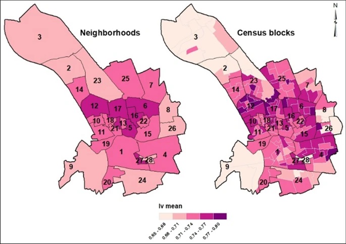
Classifying buildings according to seismic vulnerability using Cluster-ANN techniques: application to the city of Murcia, Spain
The seismic vulnerability of a city is a degree of its intrinsic susceptibility or predisposition to sustain damage or losses stemming from seismic events. In terms of physical vulnerability, one of the most important factors for assessing seismic risk, especially, for estimating losses, is the exposure of structures, particularly those structures intended for residential use.
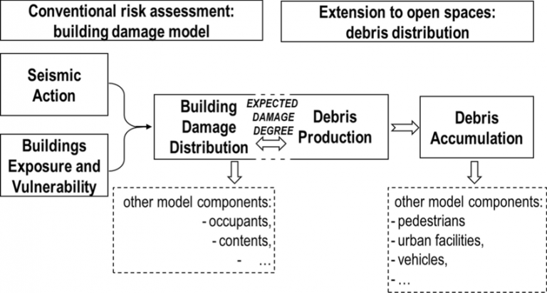
Extending urban seismic risk assessment to open spaces for the 2011 Lorca earthquake scenario
We extend the conventional seismic risk assessment approach to open spaces in the 2011 Lorca earthquake scenario. Conventional approaches to seismic risk provide estimates of damaged buildings mainly related to structural failure. The damage related to the production of debris in damaged buildings and its spread in the surrounding space receives a secondary role. However, in many cases, this secondary damage is of prime importance.
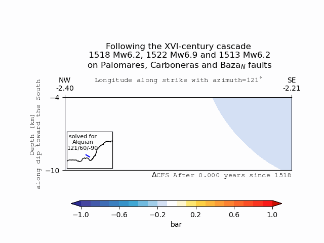
Coulomb stress transfer as an explanation for a XVI-century earthquake cascade in the Eastern Betics Cordillera, Spain; Insights from viscoelastic relaxation of the lithosphere and postseismic stress triggering.
The Eastern Betics Cordillera embraces a zone of low-to-moderate seismic activity located at the SE of the Iberian Peninsula. However, a major active fault system which crosses the area, ca. 500 km long, known as the Eastern Betics Shear Zone (EBSZ), has been responsible for the occurrence of several large historical earthquakes (Mw> 6.0) since the beginning of the historical record. Finding physics-based evidence for relations between significant historical events in such a moderate-slipping fault system would help us narrate them as long-term cascades.
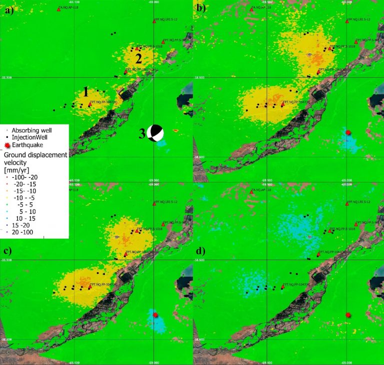
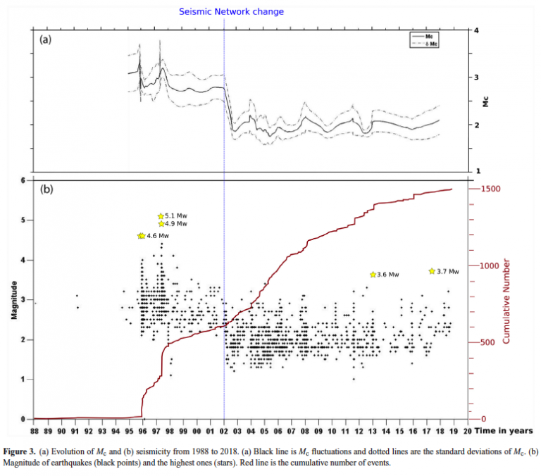
Assessment of ground deformation and seismicity in two areas of intense hydrocarbon production in the Argentinian Patagonia
The exploitation of both conventional and unconventional hydrocarbons may lead to still not well-known environmental consequences such as ground deformation and induced/triggered seismicity. Identifying and characterizing these effects is fundamental for prevention or mitigation purposes, especially when they impact populated areas.
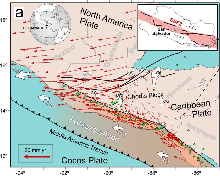
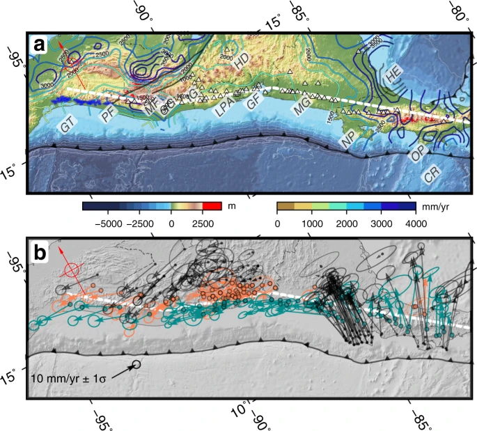
Active faults of El Salvador
In this work we present a review of the current state of knowledge of the active faults in El Salvador and its seismo-tectonic implications. An updated map of active fault traces is combined with the spatial analysis of shallow seismicity, focal mechanisms, recent geodetic GPS velocities, local strain estimations and morpho-tectonic features to provide a synoptic view of the active tectonics of the El Salvador.
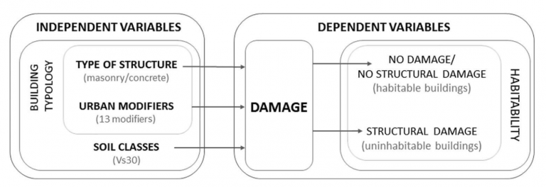
Assessing Building Habitability after an Earthquake Using Building Typology and Damage Grade. Application in Lorca, Spain
The present study proposes a statistical methodology to rate the habitability of different types of buildings after an earthquake. The first step was to rank variables that affect the vulnerability of a building and formulate a statistical study with a discrimination index that makes it possible to identify buildings as habitable or non-habitable.
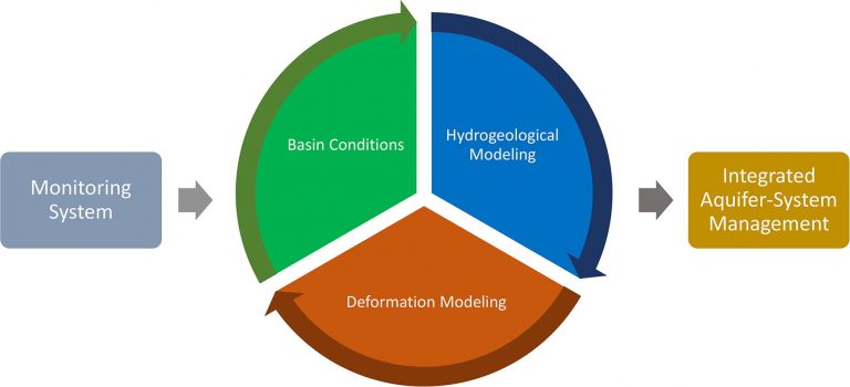
Improving multi-technique monitoring using Sentinel-1 and Cosmo-SkyMed data and upgrading groundwater model capabilities
Aquifer-systems have become a strategic source of fresh water in the present climatic conditions, especially under stress in arid regions like the Iberian Mediterranean Arc. Understanding the behavior of groundwater reservoirs is crucial to their well-management and mitigation of adverse consequences of overexploitation.